
Note: identifying details in this example have been anonymized, including vessel identity, exact position, voyage details, and raw sentence values.
A vessel approaching port is exactly the moment when navigation data should become more trusted, not less.
That is why this case is worth looking at.
The GNSS receiver was not dark. It was not obviously lost. It was still reporting a position, a time, a high satellite count, low HDOP, and a fix mode that looked reassuring at first glance.
But the raw navigation stream was telling a more complicated story.
GeoWatch also had operational context. This was not just an isolated coordinate on a map. The vessel was on a known voyage and approaching a port environment, so the GNSS evidence could be compared against route and geofence context as well as onboard motion.
The receiver said the fix was active.
It also said the navigation status was warning.
And the position was not moving normally.
TL;DR
This was a navigation-integrity warning hidden inside otherwise healthy-looking GNSS data.
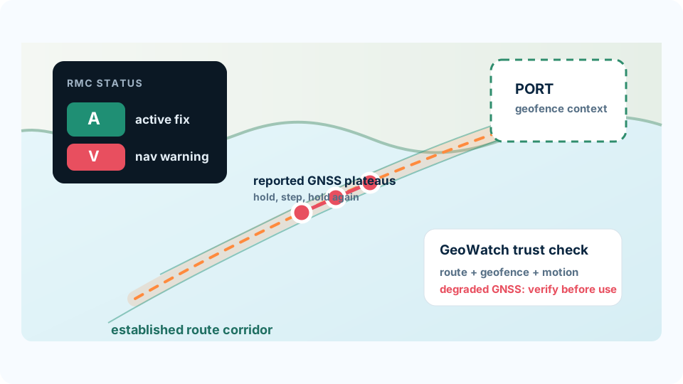
The vessel was coming into port. GGA reported many satellites and low HDOP. RMC reported A, which usually means active or valid. But the same RMC sentences also ended with V, indicating a navigation warning.
At the same time, the position held at identical coordinates for minutes, speed over ground stayed at 0.00 kn, and the coordinate only changed in small steps.
GeoWatch knew this was a port-approach situation, not just a generic offshore track. That made the anomaly more operationally important: the vessel was in a phase where stale or misleading position data can affect decisions quickly.
That combination is not a clean picture of normal vessel movement.
It is a picture of GNSS data that should be treated as degraded until independently verified.
The Confusing Part: A vs V
RMC sentences can contain more than one status-like field.
In simple terms:
Ameans the receiver has an active position fix.Vmeans void, warning, or not valid for navigation.
That distinction matters because operators and downstream systems may see the active fix and assume the navigation data is safe to use.
In this case, an anonymized representative RMC sentence looked like this:
$GNRMC,hhmmss.sss,A,llll.ll,N,yyyyy.yy,E,0.00,ccc.cc,ddmmyy,,,A,V*hh
The important fields are:
- main RMC status:
A - speed over ground:
0.00 - mode:
A - final navigation status:
V
So the short version is:
The receiver was still outputting a fix, but it was also warning that the navigation solution should not be fully trusted.
What the Position Did
The position did not behave like a smooth port approach.
Instead, the GNSS stream held the same coordinate for long periods, then stepped to a nearby coordinate, then held again.
One section of the GGA and RMC evidence showed three anonymized plateaus:
- first, the position stayed on one coordinate for several minutes
- then it stepped to a nearby coordinate
- then it stayed there for more than twelve minutes
- finally, it stepped again and held at the new coordinate
Across that pattern, reported speed over ground stayed at 0.00 kn.
That is the part that makes the case operationally interesting. A chart display may show only a small movement. A dashboard may show a live fix. But the raw evidence shows a stale or held navigation state.
Why Healthy-Looking GNSS Fields Were Not Enough
The GGA stream looked reassuring in several ways.
Satellite count was high, often around 28-36 satellites. HDOP was low, around 0.46-0.67. Fix quality was often 2, then briefly 1, then back to 2.
Those are the kinds of values that can make a GNSS solution look healthy.
But they did not match the behavior of the position.
The vessel was supposedly producing a valid, high-quality navigation solution, while the coordinate repeated exactly for minutes at a time and speed stayed at zero.
That is the lesson: satellite count and HDOP are useful, but they are not the same thing as navigation integrity.
Why Port Approach Makes It Matter
This kind of failure mode is subtle.
It is not a dramatic "GPS disappeared" event. It is a quiet trust problem.
During a port approach, crews and systems may be using navigation data for pilotage awareness, traffic decisions, passage monitoring, ECDIS context, tug coordination, and post-event reconstruction.
GeoWatch can add route and geofence context to that picture. If a vessel is on an established voyage into port, the system can treat navigation anomalies differently from the same raw GNSS pattern in open water.
That does not mean the route context proves the GNSS position is right.
It means the system has more operational context for deciding how much the anomaly matters.
If the receiver continues to output a plausible-looking position while marking the navigation state as warning, the bridge may not get the simple failure signal people expect.
The data still looks alive.
That is what makes it dangerous.
What GeoWatch Sees
GeoWatch does not only ask whether a GNSS receiver is producing coordinates.
It asks whether those coordinates still make physical and operational sense.
In this incident, the important signals were:
- repeated identical latitude and longitude values
- advancing timestamps
0.00 knspeed over ground- RMC final navigation status
V - GGA satellite and HDOP values that still looked strong
- low vessel-motion context from onboard motion data
- known voyage and port-approach context
Taken together, those signals are stronger than any single status field.
The right conclusion is not simply "the vessel drifted."
The better conclusion is: the GNSS position stream became degraded or stale, and any apparent displacement from that stream should be treated with caution.
The Takeaway
Navigation data can fail quietly.
A receiver can keep producing coordinates. It can keep showing many satellites. It can keep reporting low HDOP. It can even report an active RMC fix.
But if the same stream carries a navigation warning, repeats frozen coordinates, and reports zero speed while the position changes in steps, the data should not be trusted as ordinary vessel movement.
For port approaches, that distinction matters.
The question is not just "Do we have GPS?"
It is:
"Can we still trust what GPS is saying right now?"
Related
- Why bad navigation data can still look believable
- When Navigation Systems Look Healthy But The Data Is Wrong
- When GPS Moves But the Vessel Doesn't
- When GPS Moves in Steps While the Vessel Stays Quiet
- When Clean GPS Still Fails the Physics Check
- Why GNSS correction is not motion integrity
- Request a GeoWatch demo