
Note: identifying details in this example have been anonymized, including vessel identity, exact position, voyage details, timestamps, and raw sentence values.
Not every navigation anomaly looks dramatic.
Sometimes the track looks smooth.
That is what makes this case interesting.
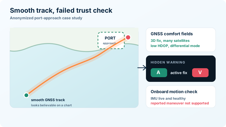
A vessel was approaching a port environment. The GNSS track looked believable at first glance: continuous movement, reasonable speed over ground, good satellite count, low HDOP, 3D fix, and differential mode.
But GeoWatch did not only look at the track.
It compared the track against receiver warning fields, route context, and onboard motion evidence.
That comparison told a different story.
TL;DR
This was not a simple frozen-position case.
The GNSS output showed a smooth port-approach track at roughly 6-7 kn. GGA and RMC positions agreed. GSA reported 3D fix and good geometry. Satellite and HDOP values looked reassuring.
But the same RMC stream carried final navigation status V, indicating warning or void status. GeoWatch also saw repeated position-jump and GPS-motion-without-IMU-activity signals while the onboard motion record remained live, healthy, and low-motion.
The result was not "confirmed spoofing."
The better conclusion is:
This was a high-priority navigation-integrity failure where the GNSS track looked usable, but the trust evidence said to verify before relying on it.
Why This Is More Subtle
A frozen GPS position is easy to explain.
A jumping position is also easy to explain.
A smooth track is harder.
On a chart, a continuous line into a port approach can look normal. The vessel appears to be moving steadily. The reported speed is plausible. The heading changes can look like ordinary maneuvering.
That is why this kind of case needs more than map review.
The track is only one piece of evidence.
The GNSS Data Looked Reassuring
Several ordinary GNSS fields looked healthy:
- GGA showed a valid-looking fix
- RMC reported an active fix
- GSA reported 3D fix
- satellite count stayed strong
- HDOP and DOP values were low
- differential mode was present
- speed over ground was plausible for a port approach
Those fields matter.
But they are not the same thing as navigation integrity.
The important contradiction was that RMC still carried final navigation status V across the same period. In simple terms, the receiver was outputting a usable-looking track while also marking the navigation solution as warning or unsafe.
That is exactly the kind of quiet failure mode that can be missed if a system only watches satellite count, HDOP, or whether coordinates are updating.
What the Motion Record Added
The onboard motion record made the case stronger.
The IMU was live. Status remained good. Updates continued. Acceleration magnitude stayed close to normal gravity. Dynamic acceleration and yaw-rate values remained low.
That does not prove the vessel was stationary.
An IMU is not a speed log. A vessel can move at steady speed without producing large acceleration. A straight run can produce very little yaw rate.
But the GNSS track was not just reporting steady translation. It included track-energy and position-jump behavior that did not have matching onboard motion evidence.
GeoWatch therefore saw a mismatch:
- GNSS reported a smooth moving track
- GNSS quality fields looked superficially healthy
- receiver warning status remained present
- position-jump indicators appeared
- onboard motion did not support the reported maneuvering
That combination is more meaningful than any one field alone.
Could This Be an IMU Problem?
Yes.
That possibility should always stay on the table.
An IMU can be poorly mounted, misaligned, isolated from the vessel structure, misconfigured, or affected by timing problems. If the IMU under-reports vessel motion, a genuine GNSS track could look suspicious.
But in this case, the IMU did not look dead or frozen. It was updating. The yaw values moved slightly. The accelerometer behaved like a live sensor. The IMU status remained good.
More importantly, the GNSS stream had its own warning signs.
The trust problem did not depend only on the IMU. It also included RMC warning status, degraded GNSS quality periods, position-jump indicators, and the earlier degraded context.
So the right operational posture is not "the IMU proves GPS is wrong."
It is:
"The navigation picture has contradictory evidence and needs independent verification."
Why Port Context Matters
GeoWatch also knew this was a port-approach context rather than an anonymous track in open water.
That matters because port approaches are decision-heavy. Crews and systems may be relying on navigation data for pilotage awareness, traffic separation, tug coordination, ECDIS context, and post-event reconstruction.
A smooth but untrusted position can be more dangerous than an obvious failure because it invites confidence.
This is where route and geofence context helps. The system does not simply ask whether GPS exists. It asks whether the navigation data still deserves trust in the operational situation where it is being used.
What This Case Shows
This case is a useful example of why navigation-integrity monitoring needs multiple layers.
If you only looked at GGA, the position might look fine.
If you only looked at GSA, the geometry might look fine.
If you only looked at the chart, the track might look fine.
If you only looked at the IMU, you might not know whether the vessel was translating smoothly.
But when those signals are combined, the picture changes.
GeoWatch saw a smooth GNSS track that failed the trust check.
The Takeaway
Navigation data does not have to look broken to be unsafe.
A GNSS receiver can report an active fix, strong satellites, low HDOP, 3D geometry, differential mode, and a smooth track while still carrying warning status and disagreeing with onboard motion evidence.
That is why the operational question is not simply:
"Does the GPS track look plausible?"
It is:
"Can we still trust this navigation picture right now?"